THRUST 01
System Architecture & O-RAN for NTN
Design L/S-band satellite radio payloads and fronthaul, predictive/cooperative beamforming and NTN-aware RU/DU/CU and RIC control for orbital mobility.
Orbital Open Radio Access Network
Advancing open, intelligent and resilient connectivity across satellite, aerial and terrestrial networks through joint communication, computation and energy-aware orchestration.
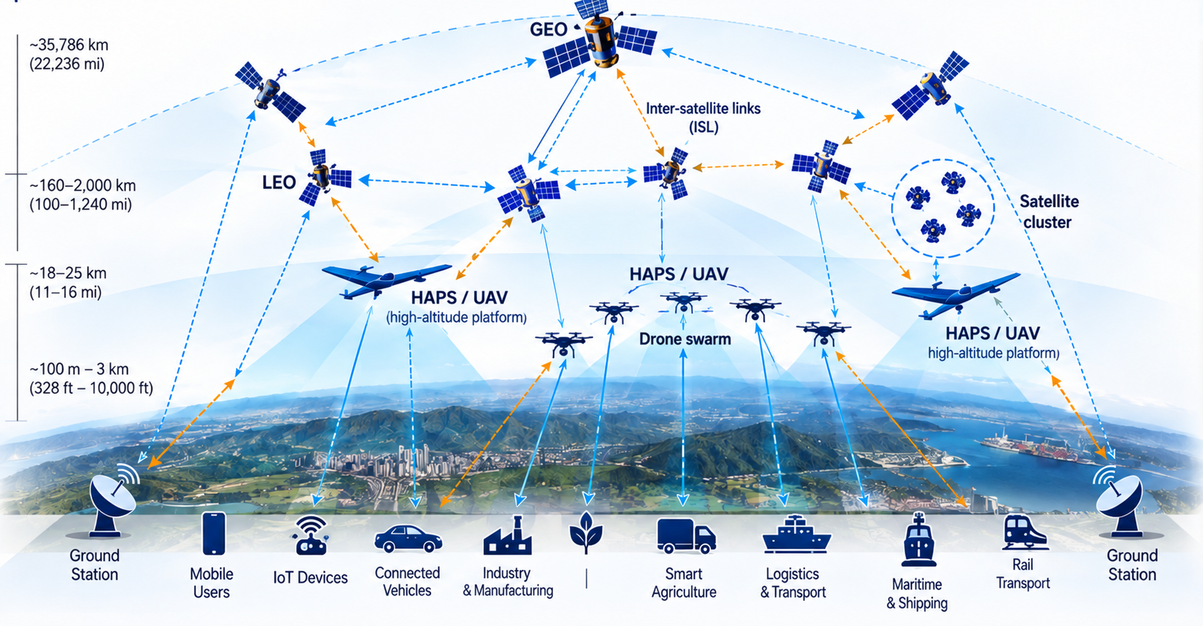
Open, predictive, compute-aware communication across space, air and ground.
O²-RAN is a collaborative NSF VINES research project developing L/S-band radio and satellite payload technology alongside AI-native, compute-aware Open RAN architectures for non-terrestrial networks. The research responds to challenges caused by orbital motion, high Doppler shifts, variable backhaul and constrained onboard computing resources.
Its vision is an adaptable and interoperable architecture that coordinates communication, computation and energy across satellites, UAVs and terrestrial infrastructure.
Learn about the projectCoordinated development of NTN-ready O²-RAN software, satellite and aerial hardware, intelligent orchestration, and integrated system validation.
Design L/S-band satellite radio payloads and fronthaul, predictive/cooperative beamforming and NTN-aware RU/DU/CU and RIC control for orbital mobility.
Develop compute-aware service models, Near-RT xApps and Non-RT rApps for predictive slicing, workload placement and edge offloading.
Integrate the full NTN O-RAN stack across mission-driven scenarios, validate KPIs and demonstrate interoperability across heterogeneous nodes.
From a working O²-RAN software stack and satellite radio hardware to AI-native control and distributed edge computing.
Project requirements and demonstrations are grounded in three representative applications.
UAV-mounted base stations restore communications in areas affected by damaged or unavailable ground infrastructure.
CubeSat-class L/S-band radio payloads and regenerative NTN functions support a planned direct-to-cell validation pathway, building toward satellite links with user devices.
Coordinated UAVs distribute sensing and AI workloads across aerial, satellite and ground edge resources.
A phased path from architecture validation to integrated space–air–ground demonstration.
Interdisciplinary collaboration with academic and industry researchers.
Johns Hopkins University
Meet the full team
Academic & industry collaboration
Peer-reviewed research, open-source tools and datasets will be posted when available.
Peer-reviewed papers, technical reports, presentations and research posters.
Content forthcomingO-RAN/NTN extensions, example configurations and publicly available research code.
Content forthcomingValidation datasets, experiment descriptions, benchmark materials and demonstration media.
Content forthcomingFor project information and research collaboration opportunities, visit the contact page.